So I wanted to post up here an outline of how the course is going to run so that people will know aproximately where I am at a perticular time.
So here it goes:
I will be heading to Lander, WY (the headquarters for NOLS) on September 16th. During those first one or two days I will be meeting course mates, organizing gear and sittind down one on one with my guides to go over my equipment. From there we will begin to package our rations for the next trip.
The first trip I will be heading out on is the backpacking section. This section will be about 10 days long and will be either in the Wind River Range or the Absaroka Mountain Ranges of WY. This will be mainly hiking, with GPS and compass work. We will be moving most of the time and covering about 60 miles or so. This is also the section I will be teaching about Mountain Ecology as part of my course requirement.
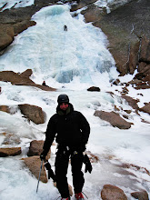
Following his trip we will head out for out climbing section. This course is alittle longer we will be out for 20-26 days depending on a variety of factors. This section is different in regards to how far we move. We will be moving between 2-3 climbing areas for a variety of skill sets and rock type. Each location we will be building a base camp and stay their for the remainder of that climbing location. Some of the spots are designated camp sites and we might be driving back and forth from the crag (rock climbing area).
After the climbing section we will head out onto the longest section, our canyonning section. This course will be anywhere from 23-30 days long and covering close to 120 miles of terrain. This is also the section of the course where we will have the ability to break into independent students trips or even solo trips (depending on our instructors permission). We will be exploring the canyons of southern Utah and northern Azizona.
The final section of the course is the winter section. This section of the course will last about 21 days and our mode of transportation will me cross country skiing with our telimark equipment. We should travel about 30 miles or so. This is the section where I will be earning my avalanche training. We will be out backcountry skiing as well as learning winter camping skills, such as building snow caves and quinzhees.
I hope this gives you guys a good idea of where to find me (mentally) good luck trying to physically find me!!!!
On my facebook event page is the mailing address where you can send mail. I will not be able to receive or send mail while out in the field (sorry pigeons dont even fly in some of the areas we are going) but I should be able to pick stuff up from headquarters when we stop back into town.
Until next time........
Subscribe to:
Post Comments (Atom)
No comments:
Post a Comment